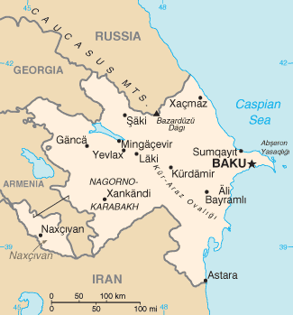
File:Aj-map.png
Appearance
Aj-map.png (325 × 349 pixels, file size: 13 KB, MIME type: image/png)
File history
Click on a date/time to view the file as it appeared at that time.
| Date/Time | Thumbnail | Dimensions | User | Comment | |
|---|---|---|---|---|---|
| current | 07:44, 19 February 2022 |  | 325 × 349 (13 KB) | Lojwe | Cropped 1 % horizontally, 1 % vertically using CropTool with precise mode. |
| 12:44, 5 August 2015 |  | 328 × 352 (14 KB) | Ray Garraty | Reverted to version as of 22:26, 26 February 2005 | |
| 12:11, 5 August 2015 |  | 328 × 352 (43 KB) | Szczureq | Added border of Armenian-controlled Nagorno-Karabakh territory | |
| 22:26, 26 February 2005 |  | 328 × 352 (14 KB) | Alfio | Cia map of Azerbaijan |
File usage
The following page uses this file:
Global file usage
The following other wikis use this file:
- Usage on ab.wikipedia.org
- Usage on af.wikipedia.org
- Usage on ast.wikipedia.org
- Usage on av.wikipedia.org
- Usage on azb.wikipedia.org
- Usage on az.wikipedia.org
- Usage on be-tarask.wikipedia.org
- Usage on be.wikipedia.org
- Usage on bg.wikipedia.org
- Usage on bg.wiktionary.org
- Usage on br.wikipedia.org
- Usage on bs.wikipedia.org
- Usage on ca.wikipedia.org
- Usage on cs.wikipedia.org
- Usage on cv.wikipedia.org
- Usage on da.wikipedia.org
- Usage on de.wikipedia.org
- Usage on dsb.wikipedia.org
- Usage on el.wikipedia.org
- Usage on en.wikipedia.org
- Branobel
- SOCAR
- Dunsterforce
- Shah Deniz gas field
- Portal:Azerbaijan
- Portal:Azerbaijan/Azerbaijan-related topics
- Azeri–Chirag–Gunashli
- Extreme points of Azerbaijan
- Azerbaijan International Operating Company
- List of airports in Azerbaijan
- Darwin Bank
- Energy in Azerbaijan
- Karabakh oilfield
- Caspian International Petroleum Company
- Chirag oilfield
View more global usage of this file.


