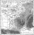
File:France1911topo.png
Jump to navigation
Jump to search

Size of this preview: 572 × 599 pixels. Other resolutions: 229 × 240 pixels | 458 × 480 pixels | 733 × 768 pixels | 977 × 1,024 pixels | 1,840 × 1,928 pixels.
Original file (1,840 × 1,928 pixels, file size: 3.28 MB, MIME type: image/png)
File history
Click on a date/time to view the file as it appeared at that time.
| Date/Time | Thumbnail | Dimensions | User | Comment | |
|---|---|---|---|---|---|
| current | 15:33, 26 April 2014 |  | 1,840 × 1,928 (3.28 MB) | LlywelynII | {{Information |Description ={{en|1=A topographical map of France c. 1911}} |Source ="France" in the ''Encyclopædia Britannica'', 11th ed. 1911. |Author =Credited to Emery Walker |... |
File usage
The following 2 pages use this file:


