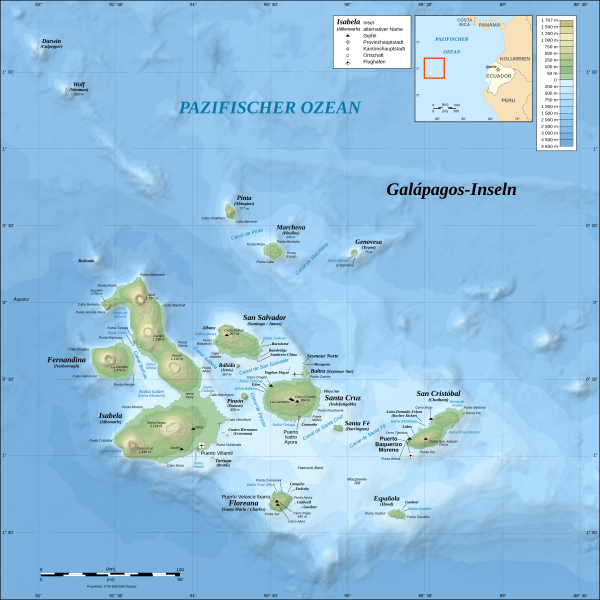
File:Galapagos Islands topographic map-de.svg
Appearance

Size of this PNG preview of this SVG file: 600 × 600 pixels. Other resolutions: 240 × 240 pixels | 480 × 480 pixels | 768 × 768 pixels | 1,024 × 1,024 pixels | 2,048 × 2,048 pixels | 2,160 × 2,160 pixels.
Original file (SVG file, nominally 2,160 × 2,160 pixels, file size: 2.62 MB)
File history
Click on a date/time to view the file as it appeared at that time.
| Date/Time | Thumbnail | Dimensions | User | Comment | |
|---|---|---|---|---|---|
| current | 17:36, 11 June 2016 |  | 2,160 × 2,160 (2.62 MB) | NordNordWest | Bahia Tortuga corrected |
| 19:33, 3 November 2008 |  | 2,160 × 2,160 (2.62 MB) | NordNordWest | corrected | |
| 17:07, 26 October 2008 |  | 2,160 × 2,160 (2.62 MB) | NordNordWest | {{Location|00|30|00|S|90|30|00|W|scale:1000000}} <br/>{{Information |Description= {{de|Topografische and bathymetrische Karte der Galápagos-Inseln, Ecuador.}} {{en|Topographic and bathymetric map of the [[:en:Gal |
File usage
The following page uses this file:
Global file usage
The following other wikis use this file:
- Usage on af.wikipedia.org
- Usage on cs.wikipedia.org
- Usage on de.wikipedia.org
- Usage on de.wikivoyage.org
- Usage on eo.wikipedia.org
- Usage on es.wikipedia.org
- Usage on fo.wikipedia.org
- Usage on frr.wikipedia.org
- Usage on hu.wikipedia.org
- Usage on it.wikipedia.org
- Usage on it.wikivoyage.org
- Usage on ko.wikipedia.org
- Usage on nn.wikipedia.org
- Usage on ro.wikipedia.org
- Usage on sl.wikipedia.org
- Usage on stq.wikipedia.org
- Usage on war.wikipedia.org


