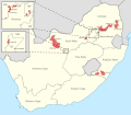
File:South Africa 2006 provincial border changes map.svg
Appearance

Size of this PNG preview of this SVG file: 686 × 600 pixels. Other resolutions: 275 × 240 pixels | 549 × 480 pixels | 878 × 768 pixels | 1,171 × 1,024 pixels | 2,342 × 2,048 pixels | 1,123 × 982 pixels.
Original file (SVG file, nominally 1,123 × 982 pixels, file size: 591 KB)
File history
Click on a date/time to view the file as it appeared at that time.
| Date/Time | Thumbnail | Dimensions | User | Comment | |
|---|---|---|---|---|---|
| current | 19:21, 4 March 2014 |  | 1,123 × 982 (591 KB) | Htonl | remove the tiny enclave of KZN inside EC - it was actually incorporated in EC since 1994 |
| 19:55, 18 February 2014 |  | 1,123 × 982 (592 KB) | Htonl | projection and style | |
| 22:34, 4 February 2010 |  | 1,000 × 786 (1.19 MB) | Htonl | {{Information |Description={{en|1=Map showing the changes made to the borders of South Africa's provinces on 1 March 2006 by the Twelfth Amendment to the Constitution. Solid lines indicate the borders after the changes; dashed lines indicate changed borde |
File usage
The following page uses this file:
Global file usage
The following other wikis use this file:
- Usage on en.wikipedia.org
- Usage on ro.wikipedia.org
- Usage on ru.wikipedia.org

