Ptolemy were translated into Arabic, and in 827, in the reign
of the caliph Abdullah al Mamun, an arc of the meridian was
measured in the plain of Mesopotamia. Most famous among
these Arabian astronomers were Al Batani (d. 998), Ibn Yunis of
Cairo (d. 1008), Zarkala (Azarchel), who determined the meridian
distance between his observatory in Toledo and Bagdad to
amount to 51° 30′, an error of 3° only, as compared with Ptolemy’s
error of 18°, and Abul Hassan (1230) who reduced the great
axis of the Mediterranean to 44°.
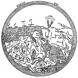
Further materials serviceable to the compilers of maps were supplied by numerous Arabian travellers and geographers, among whom Masudi (915–940), Istakhri (950), Ibn Haukal (942–970), Al Biruni (d. 1038), Ibn Batuta (1325–1356) and Abul Feda (1331–1370), occupy a foremost place, yet the few maps which have reached us are crude in the extreme. Masudi, who saw the maps in the Horismos or Rasm el Ard, a description of the world by Abu Jafar Mahommed ben Musa of Khiva, the librarian of the caliph el Mamun (833), declares them to be superior to the maps of Ptolemy or Marinus, but maps of a later date by Istakhri (950) or Ibn al Wardi (1349) are certainly of a most rudimentary type. Nor can Idrisi’s map of the world, which was engraved for King Roger of Sicily upon a silver plate, or the rectangular map in 70 sheets which accompanies his geography (Nushat-ul Mushtat) take rank with Ptolemy’s work. These maps are based upon information collected during many years at the instance of King Roger. The seven climates adopted by Idrisi are erroneously supposed to be equal in latitudinal extent. The Mediterranean occupies nearly half the inhabited world in longitude, and the east coast of Africa is shown as if it extended due east.
The Arabians are not known to have produced a terrestrial globe, but several of their celestial globes are to be found in our collections. The oldest of these globes was made at Valentia, and is now in the museum of Florence. Another globe (of 1225) is at Velletri; a third by Ibn Hula of Mosul (1275) is the property of the Royal Asiatic Society of London; a fourth (1289) from the observatory of Maragha, in the Dresden Museum, two globes of uncertain age at Paris (see fig. 17) and another in London. All these globes are of metal (bronze), or they might not have survived so many years.
The charts in use of the medieval navigators of the Indian Ocean—Arabs, Persians or Dravidas—were equal in value if not superior to the charts of the Mediterranean. Marco Polo mentions such charts; Vasco da Gama (1498) found them in the hands of his Indian pilot, and their nature is fully explained in the Mohit or encyclopaedia of the sea compiled from ancient sources by the Turkish admiral Sidi Ali Ben Hosein in 1554.[1] These charts are covered with a close network of lines intersecting each other at right angles. The horizontal lines are parallels, depending upon the altitude of the pole star, the Calves of the Little Bear and the Barrow of the Great Bear above the horizon. This altitude was expressed in isbas or inches each equivalent to 1° 42′ 50″. Each isba was divided into zams or eights. The interval between two parallels thus only amounted to 12′ 51″. These intervals were mistaken by the Portuguese occasionally for degrees, which account for Malacca, which is in lat. 2′ 13″ N., being placed on Cantino’s Chart (1502) in lat. 14′ S. It may have been a map of this kind which accounts for Ptolemy’s moderate exaggerations of the size of Taprobana (Ceylon). A first meridian, separating a leeward from a windward region, passed through Ras Kumhari (Comorin) and was thus nearly identical with the first meridian of the Indian astronomers which passed through the sacred city of Ujjain (Ozere of Ptolemy) or the meridian of Azin of the Arabs. Additional meridians were drawn at intervals of zams, supposed to be equal to three hours’ sail.
In China, maps in the olden time were engraved on bronze
- ↑ M. Bittner, Die topogr. Capital des ind. Seespiegels (Vienna, 1897).


