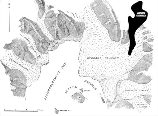
Fig. 13. Map of the lower fifth of Hubbard Glacier and adjacent ice tongues (after Gannett, Harriman Expedition, and Rich, U. S. Geol. Survey). The whole Rhone Glacier in Switzerland is drawn in black on exactly the same scale for comparison. The hitherto stagnant Variegated Glacier (on the right) and the Haenke Glacier (on the left) became crevassed and advanced between 1905 and 1906, the front of the latter moving nearly a mile in less than nine months and becoming tidal. In 1909 it once more ended on the land. A slight continuation of the advance of Hubbard Glacier would separate Russell Fiord from Disenchantment Bay and the Pacific Ocean.
(Fig. 14) which would be 33 miles long and 100 square miles in area. Its surface would be higher than the present fiord and would receive icebergs from four or more great glaciers, only one of which is now tidal. What would happen to the stagnant, moraine-veneered terminus of Variegated Glacier is a problem. The glacial lake would drain to the Pacific independently until future retreat of Hubbard Glacier resulted in the restoration of the lake to the fiord.
This renewal of activity by Hubbard Glacier is, therefore, of more than ordinary interest, especially as the advance is one of the type now well proved to be due, not to climatic variation, but to excessive avalanching during earthquakes.


