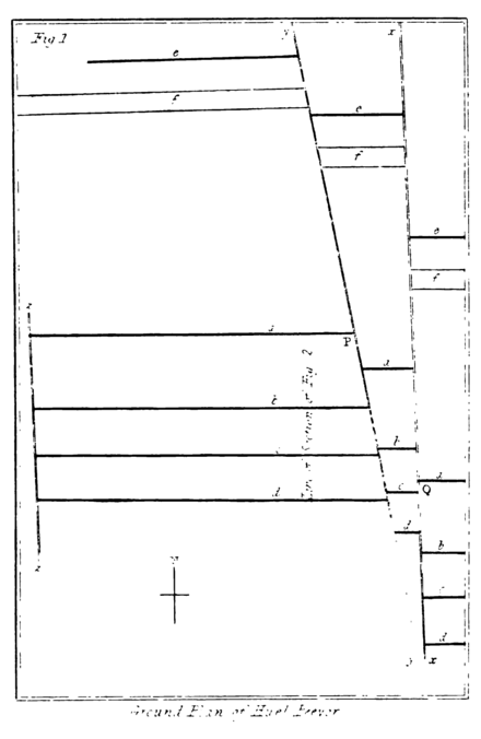
By a reference to the accompanying ground plan of the mine, Pl. 7, fig. 1, it will be seen that it consisted of one tin vein a and one copper vein b; the latter called John's Gossan, running in the direction of east and west, and forty fathoms south of the former; two other veins c and d not metalliferous, took the same direction, one 25 fathoms south of the copper vein, and the other 28 fathoms still further south. Many fathoms north of the tin vein, but at what exact distance is not precisely known, a channel of porphyry; or in the language of the miner, of elvan, also ran in the direction of east and west, and a copper vein c near it. It will also be seen that there were three cross veins, not metalliferous, technically called cross courses, the easternmost of which x runs from 10 degrees west of north to 10 degrees east of south, that next to it y, about 9 fathoms to the west, runs a little more to the west of north, and east of south. The precise direction of the westernmost z, which was 145 fathoms distant from that next to it on the east, is not known; nor is that essential to the present object, since as it formed the utmost limits of the workings of the mine on the west, and was situate in the poorest part, it was not found to contribute any thing towards the strange circumstances which have rendered the history of this mine so well deserving of detail and preservation.
The tin vein a is from three to thirty feet wide, but its general average may be estimated at about eight feet. The copper vein b is about three feet wide. It is almost needless to observe that these veins were not equally productive in every part; in some places, they were very rich, in others quite poor; but it is worthy of notice, that where the tin vein was thirty feet wide, its substance consisted of a mass of rich tin ore extending several fathoms in every direction. The substances enclosed in the copper vein, consisted, near the surface, of quartz and iron ochre, or gossan, amongst which was interspersed

